My current lunchtime game is Scales of Truth, a hexcrawl set in a post-apocalyptic science-fantasy setting. Think of a mashup of Thundarr the Barbarian, Expedition to the Barrier Peaks, and Mad Max: Fury Road, powered by Dungeons & Dragons.
So what’s a hexcrawl? It’s a style of RPG campaign in which the game master populates a large regional map (usually divided into hexes). The players start off in a particular area and then explore the region. Each hex typically has a location or encounter of note that can be discovered, but that’s not guaranteed. The default hex size varies, but for our campaign, I’m using 6-mile hexes, which fits with D&D’s overland travel rules.
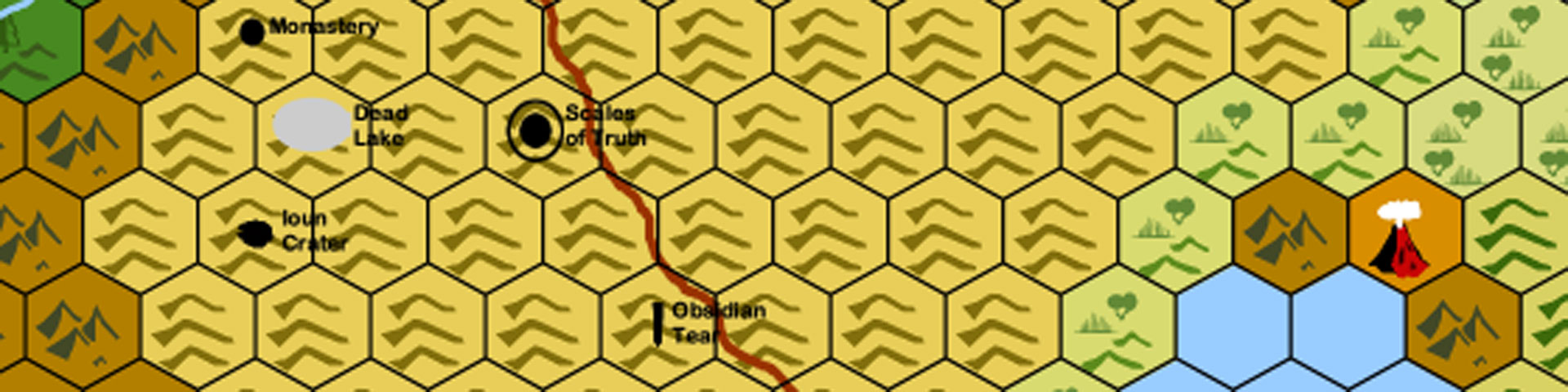
Scales of Truth is a homegrown campaign setting in which our protagonists explore the Serpent Hills, a region once ruled by an ancient reptilian empire. That empire fell to ruin and left behind myriad technological and arcane artifacts.
It’s my first hexcrawl, and my first attempt at creating a true hex map of a region. I did a ton of mapping for the Blackrazor Guild’s signature campaign back in the day, but that was more at the “country” level with large regional maps or the city level, with street-by-street details.
A hexcrawl … well, that’s something else. I contemplated doing one for several years before getting started – mostly because getting started was the hardest part. I found myself paralyzed by an irrational fear of “getting it wrong”. That’s dumb – I mean, it’s my map, so who knows if it’s wrong? But still, I spent a hell of a lot of time looking for hexcrawl resources as an excuse not to start my own.
Drawing the Map on a Hex Grid
The Scales of Truth campaign finally pushed me into action by giving me the starting concept: the aforementioned Serpent Hills. After some brainstorming, first by myself, then with the campaign players, I knew that the campaign would begin in at the Scales of Truth, an ancient library ruled by a dragon who hoarded knowledge instead of gold. The Serpent Hills, and its prior reptilian rulers, implied things about the region and climate. It was dry and isolated, which meant there were likely mountains and other geographic barriers shielding it from the larger world. With that spark, and resolving not to let myself get paralyzed by the choices before me, I started drawing.
I sketched the original draft of the map on hex graph paper, quickly putting down the Serpent Hills, the Shield Mountains on its north/south/west border, and some jungles to the south. I sketched out what lie beyond the Shield Mountains to the west, but left most of the eastern side of the map blank.
Converting to a Digital Hexcrawl
Wanting something to share with my players, I started recreating it digitally using Hexographer. I finished of the map to share it as a resource in Roll20, and then got busy with life and gaming. During the game I periodically jotted down location notes in my bullet journal, indicating where new wonders or horrors could be found. Sometimes, I even remembered to update the map.
As a result of my haphazard cartography, something interesting happened: the map in my head, the map on paper, and the map in Hexographer … drifted. Case in point: the Tower of Daar Kimbatuul, home to the reclusive dragonborn author of On the Mutations of Flora in the Caverns of Kazeal and numerous other scientific tomes.
I thought the tower was on the southern edge of the Serpent Hills, near the unnamed jungles. But on the map, I’d put it along the western edge, near the Shield Mountains. This led to one memorable session (at least for me) where I realized my mistake, and retconned the tower to lie to the south. There have been other minor transcription errors as well. Skull Keep, home to human roadwarrior-types, and Iron Crown, a dwaven fortress town built in a crater, were two hexes apart on the hand-drawn map, but only one hex separated them on the Hexographer version.
Cartographic Uncertainty
Then I upgraded from Hexographer to its successor, Worldographer. There were a few layout glitches when converting the map, but as I worked through them I realized that I’d made more fundamental mistakes when creating the original digital version. I owned up to this with my players, explaining that the map they were looking at was more a suggestion of the world than the literal truth.
While the lack of cartographic uncertainty could be frustrating, I embraced it. If you think about it, such inaccuracy is in keeping with real-world map-making, particularly in medieval times. There could be large digressions between regional maps done by different cartographers at different times. It also fits my own experience in backpacking. Even with a good map, you can underestimate how long it will take to get from Point A to Point B or take a wrong turn that takes you down a different trail. Heck, with an outdated map, you can find yourself looking for a bridge that doesn’t exist … or maybe never existed! (I’m looking at you, Jacosburg State Park!)
Reconciling the Hand-drawn vs. Digital Hexcrawl
Over the holiday break, I dedicated an afternoon to reconciling my maps and updating the player version based on what they’ve discovered during the last nine months of the campaign. It’s accurate now (or at least, I think it is). During this process, I realized an even more fundamental mistake in misnumbering my hexes – the hex offset in my paper map was different from my digital map, which magnified certain other errors over time.
It’s all reconciled now, and I’m feeling pretty good about the current map. Based on past experience, I’m sure that 1) I’ve made a few mistakes and 2) new discrepancies will find their way into the map over time.
And that’s ok. A little uncertainty adds to the mystery of the campaign and reflects the characters’ own imperfect knowledge of the world (as well as the dungeon master’s)
Featured Image Meta
A small portion of the Serpent Hills, as mapped using Worldographer. Credit: Ken Newquist